Fosterville, or Foster's Corner as it was first known, is located about 20 miles from Canterbury and two miles northwest of Green Mountain. Although a community within its own right, Fosterville shares with Green Mountain a undefined boundary somewhere on the Mountain Hill. If one went by where children attended school, it would appear the line is near the top of the hill. On the Canterbury side, the village limit is somewhat obscure. From the Sam Foster hill to Graham's Corner, about three miles, is closely associated with Fosterville, although this strip has been known variously as "The Head of the Lake" and "Eel River". To confuse the matter even more, Eel River (a stream as well as a settlement) is located a couple of miles further east. No wonder most people simple referred to the overall name of North Lake.
Indications are that the first settlers in Fosterville were brothers David and Josiah Foster who obtained grants of land. They probably came to the area around 1860 in search of lumber, particularly the white pine for ships' masts. Certainly surveyors had been in this area as early as 1797 when they mapped out North Lake, but it would be some time before anyone would actually settle in such a remote corner. Some of the early residents felt a railroad would add much to the area, but the closest it would ever come in New Brunswick would be Canterbury and Forest Station in Maine.
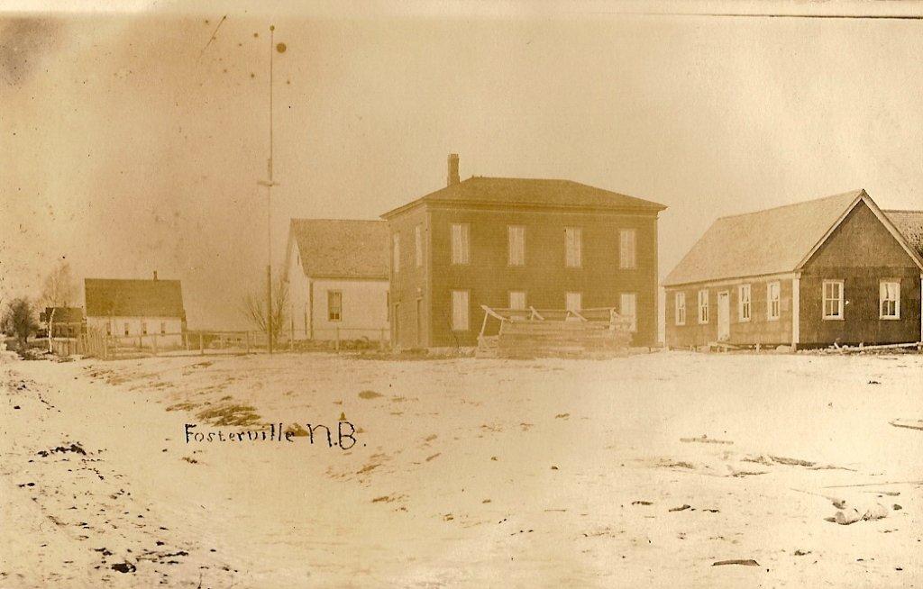
A land map of 1877 indicates there were two stores, a school house, a Methodist Church, and a Hall, probably the Loyal Orange Lodge No. 50. From the border the land grantees were: Bartlett, Cropley, McMinn, H. McMinn, and D. Foster. From the corner to the Sam Foster Hill were: Maxon, Collier, Maxon, Foster, and S.M. Foster. The post office, 1889-1970, was located first in the big house at the corner, later owned by Sam Collier who passed it to his daughter, Edith. Mail delivery before this came from Canterbury, probably on a weekly basis.
Situated on a elevated knoll overlooking the northern end of Grand Lake, Fosterville boasted one of the finest beaches around. Sandy bottom and gradual descent made it a haven for all type of water activities and remains so today. Cottages line the shore. In fact, the summer population of 1995 probably exceeds that of 100 years ago.
Continuing towards Canterbury, on the shore of North Lake, a ribbon development along the highway of about three miles. The locals often referred to this area as "The head of the Lake." Fosters owned the property where Emery Armour's house now stands; across the road, a Farrell whose descendant, Paul Farrell, still lives. Further on we find Gold ("Gould"), R. Clarke, Welsh, Dean, School House, C. Clarke, Foster, Smith, Dean, Dan Graham, Graham, Foster, E. Varney, Varney, Dickinson, MacArthur, Dickinson, Bubar, School House, Wilson, Cunningham, Gold (See Gould), Flemming and English.
At Graham's Corner, sometimes called Eel River, a road went north to Maxwell, Kirkland, and eventually came out at Richmond Corner. The main road from Graham's corner continued on to Eel River Lake, Canterbury and the Saint John River road.
Fosterville did not have an industrial base. People made their living off small farms and woods work. And some earned a small wage working on behalf of the York County Council as a keeper of vital statistics, road superintendent, tax collector and so on. When the political party changed, so did the people in these positions. Some families were better off than others but downright poverty was minimal.
Cottages dotted the shore of Grand Lake. Many of the originals are still there today, but the new ones now run into six figures to buy a lot and another six figures to build.